Stalled weather: how stuck air pressure systems drive floods and heatwaves
Steve Turton' CQUniversity Australia
Climate change – fuelled by increasing greenhouse gases – is causing more extreme weather events worldwide.
Many of these events' such as the "rain bomb" inundating Australia's east coast and the recent heatwave in Western Australia' are associated with "stalled" weather systems.
Normally' Australia's weather systems are driven from west to east by jet streams: narrow bands of fast-flowing air high up in the troposphere' the lowest layer of Earth's atmosphere.
But when weather systems stall in a particular place' usually because of "blocking" high-pressure systems that stop them moving on' they can produce devastating extended periods of heat' cold or rain. As the climate continues to change' these stalled weather systems are expected to get bigger.
Stalled weather systems
Blocking systems are persistent high-pressure systems combined with one or two low-pressure systems.
High-pressure systems (where air pressure is relatively high) are associated with clear and dry weather' while low-pressure systems are associated with rising air' cloudiness and rain
Blocking tends to be less persistent in the southern hemisphere than the northern as the westerly jet streams are stronger.
Blocking highs are mostly associated with a region of low pressure to the north of the system. Together' the two systems work against each other to effectively "stall" the weather.
Depending on where they occur' blocking systems may cause consistent heatwaves' cold spells' floods and dry spells. They are often associated with record-breaking weather events and human deaths – for example' the deadly heatwaves in France in 2003 and Russia in 2010.
In 2021' persistent blocking systems were responsible for the North America cold wave in February and the record-shattering Western North America heatwave in June and July. The latter event caused some of the highest temperatures ever recorded in the region' including the highest temperature ever measured in Canada at 49.6℃.
Slowing jet streams
Blocking events in the northern hemisphere are often associated with slowing or meandering jet streams. This occurs when the polar vortex – a large region of low pressure and cold air around the pole – breaks down.
While the exact mechanisms driving the slowing of mid-latitude jet streams is debated' the consensus attributes it to "Arctic amplification".
The Arctic region is currently warming two to three times faster than the rest of the world. This different rate of atmospheric warming between the Arctic and tropics results in a weaker atmospheric pressure gradient and slows down the jet streams.
Stalled weather in Australia
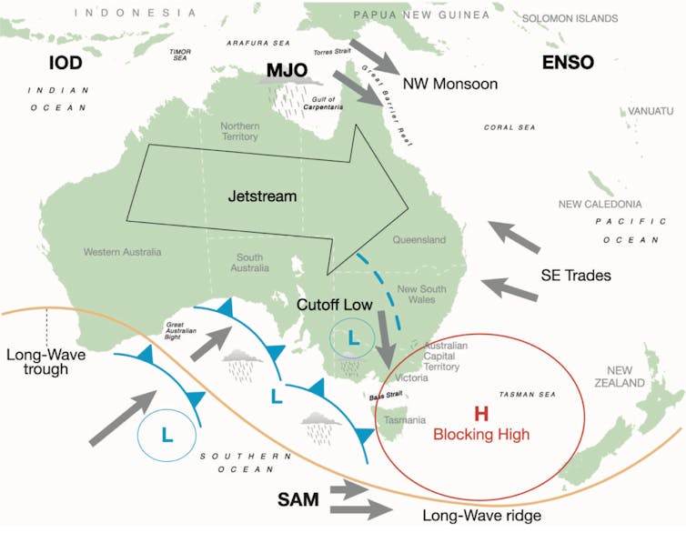
Blocking highs in the Australian region usually occur in the Great Australian Bight and the Tasman Sea. These strong high-pressure systems typically form further south than usual.
These highs remain almost stationary for an extended period' blocking the normal easterly progression of weather systems across southern Australia. They can occur at any time of year' and usually stay in the Australian region for several days to several weeks.

A blocking high in the Tasman Sea caused record heatwaves in Australia in 2019. Bureau of Meteorology
A prolonged blocking high in the south Tasman Sea in January and February 2019 caused record heatwaves for many inland towns in Australia. Adelaide recorded the hottest day for any Australian capital city (46.6℃) on January 24.
The same blocking high prevented the movement of a deep monsoon low in North Queensland' resulting in the equivalent of a year's rain in a week over the Townsville area in early February 2019.
The rain bomb
In late February 2022' a stalled weather system caused heavy rain and flooding over large parts of Southeast Queensland and Northern NSW. A stubborn blocking high near New Zealand prevented it moving away to the east.
A region of low pressure in the upper atmosphere became cut off from the westerly air current further south' creating a trough of low pressure at surface level. This created the perfect mix of upper and surface atmospheric conditions for what has been called a "rain bomb" or a "river in the sky".
The rain bomb caused extensive major flooding.
Brisbane' the country's third-largest city' smashed its three-day record with 677mm of rain. Over four days' the city recorded 741mm – almost three-quarters of its annual average rainfall!
The city endured flooding similar to the disastrous 2011 floods. More than 15'000 homes are estimated to have been inundated in Brisbane by the current event.
The Brisbane River peaked at 3.85 metres' below the 4.46 metres experienced in 2011. However' the two flood events are very different' and some suburbs experienced worse flooding than in 2011.
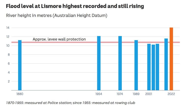
Gympie' north of Brisbane' and Lismore in northern NSW experienced catastrophic flooding of their central business districts. Gympie has endured its worst flood in 120 years and Lismore its highest ever recorded flood level' smashing the previous record by about 2 metres.

Lismore's February 2022 flood smashed the previous record. Bureau of Meteorology
Future events
Recent research has shown extremely high rainfall' and flooding events' will become more likely as the atmosphere and oceans warm under climate change.
What does this mean for the future? Can we expect more rain bomb events? Will we continue to witness more rainfall and flood level records in Australia and globally?
The answer to all these questions is yes' and rising greenhouse gases and warming of the atmosphere and oceans are to blame.
The rise in average global temperatures has driven more extreme rainfall events since the 1950s. Australian land areas have warmed about 1.4℃ since 1910.
A warmer atmosphere can hold more water. For every 1℃ of extra warming' about 7% more water can be saved as water vapour. Given the right atmospheric triggers' vast amounts of stored water can be released as heavy rainfall over unsuspecting human communities.
The jury is out regarding the effects of global warming on high-pressure blocking systems.
Currently' climate models tend to underestimate both the frequency and duration of blocking events. Scientists continue to grapple with this problem in their models' and it forms the basis of ongoing research.
However' one study found climate change will increase the size of stalled high-pressure weather systems in the northern hemisphere by as much as 17% this century.
In the case of an extensive high-pressure system' this will cause impacts such as heat and cold waves over larger geographical areas' affecting more people.

Steve Turton' Adjunct Professor of Environmental Geography' CQUniversity Australia
This article is republished from The Conversation under a Creative Commons license. Read the original article.
